In August 2022, significant flooding occurred in the Hanby Park and Clouston Terrace area. To reduce the chance of flooding occurring in this area in the future, Council started work to come up with solutions to improve flood resilience.
In August 2024, it was announced that Nelson would receive $9 millions to support projects, including the flood resilience projects in this area.
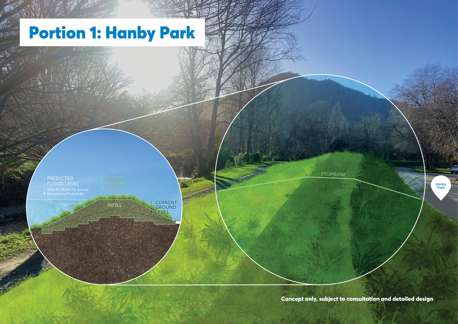
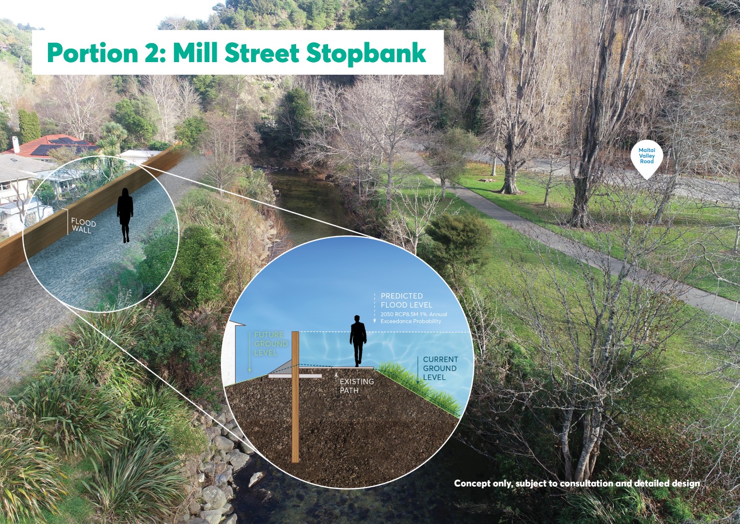
Working with our expert consultants Tonkin and Taylor, the team has come up with a range of options to reduce the risk of flooding. This includes raising stopbanks, installing flood walls, and expanding the floodway into Branford Park.
We are currently talking with residents who are directly affected and will be taking their feedback on board as we progress the designs.
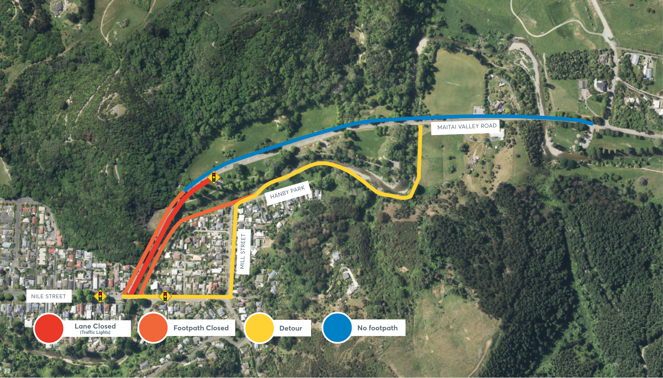
Pedestrian detour
There's multiple projects underway in the Maitai that require a pedestrian detours.
Along Maitai Valley Road is the installation of pipes and a shared pathway.
Along Hanby Park is a flood mitigation project.
Both walkways are currently closed. The detour route is along Mill Street (yellow line below).
Cyclists: you must use the traffic light system, as there is not enough space on Maitai Valley Road to safely pass oncoming traffic

Frequently asked questions
In the August 2022 weather event, significant flooding occurred in the Hanby Park and Clouston Terrace area. To reduce the chance of future flooding in this area, Council has been working to come up with solutions to improve flood resilience.
This project will reduce the risk of future flooding. There are five ways we are hoping this will be achieved. This includes:
· New floodwalls
· Upgrading existing stopbanks
· Increasing the capacity of the river channel
· Reducing stormwater overflows from Cleveland Terrace. (Upgrade of the intake is currently in progress).
· Reducing the backflow through the stormwater network that occurs due to high river levels. This involves re-directing stormwater flows on Nile Street East (West of Clouston bridge)
Council has already installed additional non-return valves in the stormwater network in the Mill Street area to reduce risk of backflow through sumps and culverts due to high river levels. This was a reported issue in August 2022.
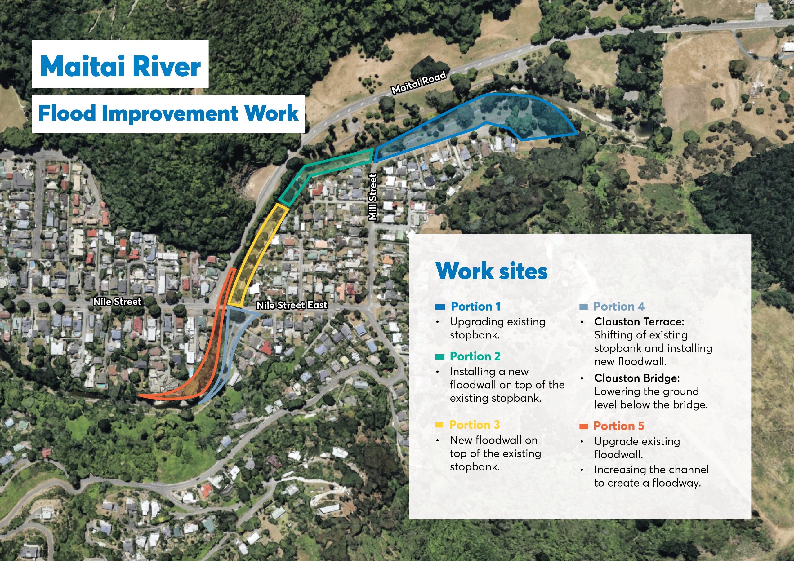
Four individual projects make up the wider Maitai Flood Resilience project. This overall project includes
· Stormwater intake upgrade on Cleveland Terrace
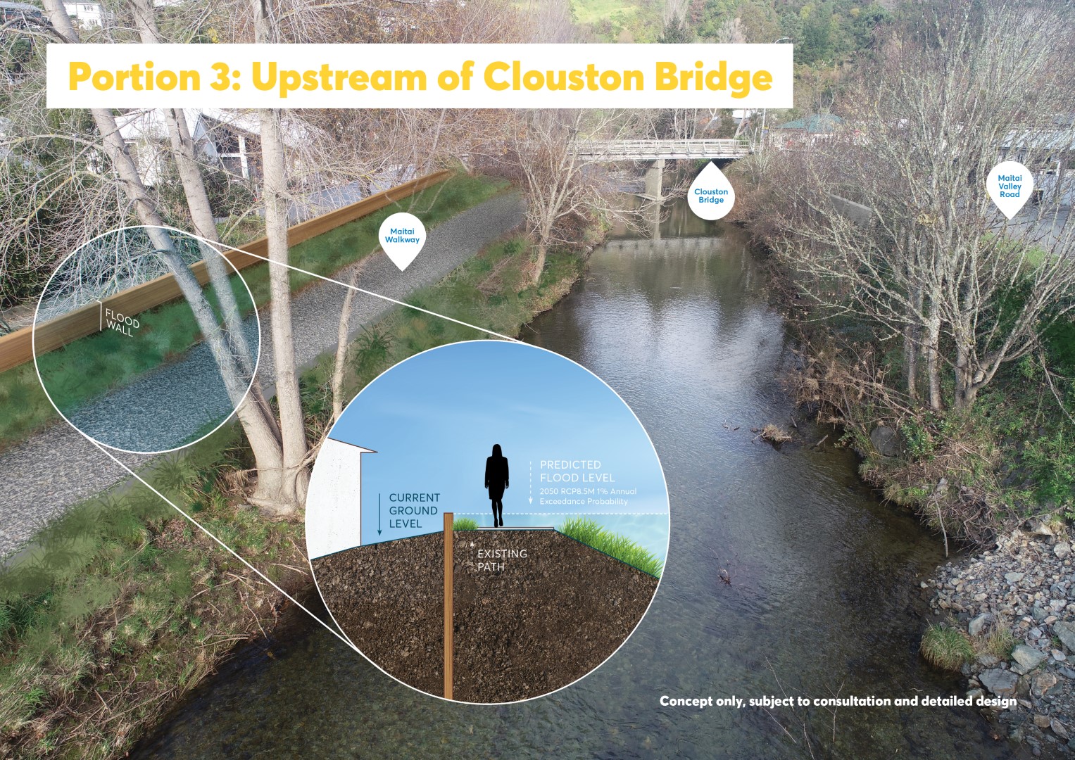
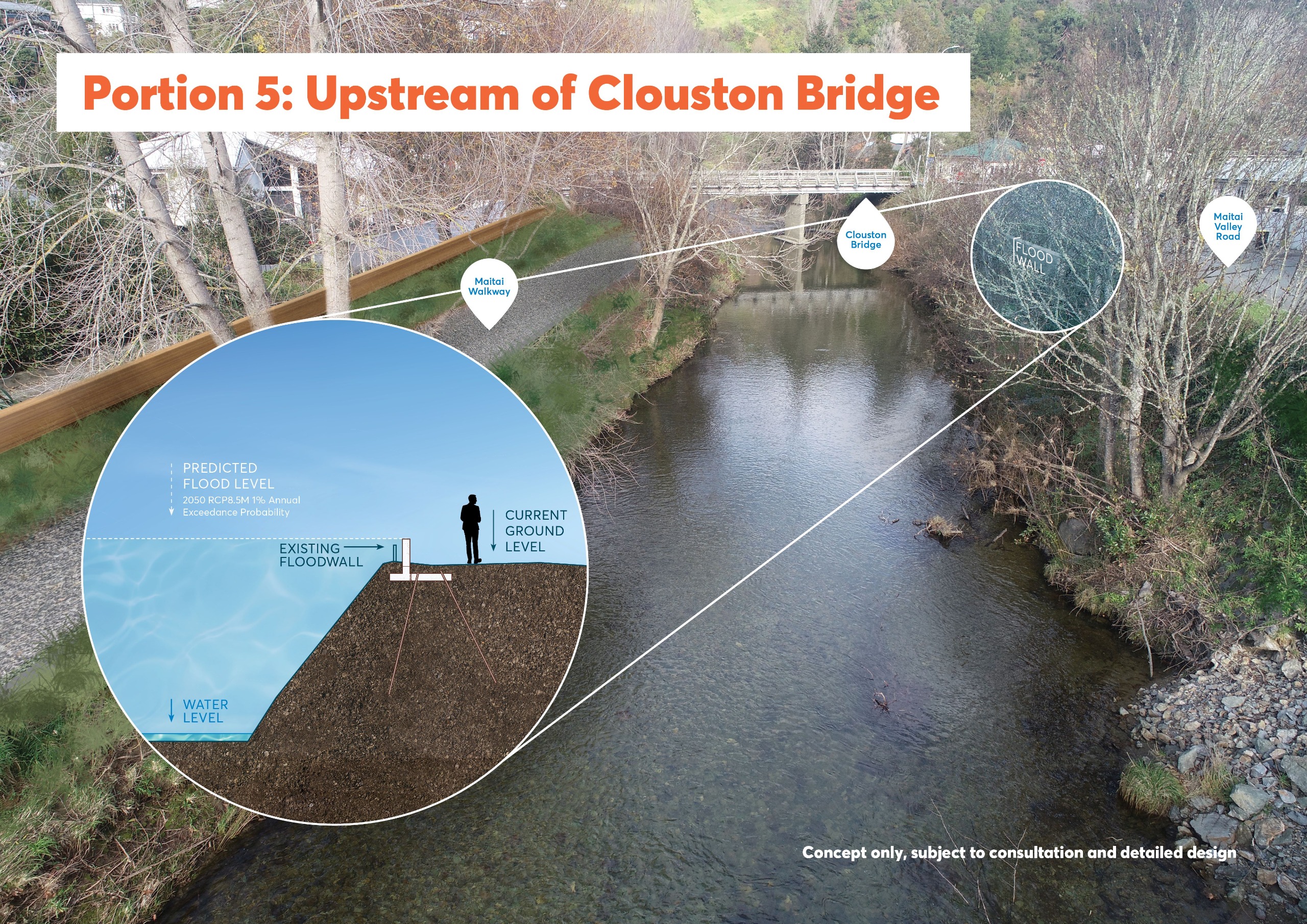
· Stopbank improvements from Hanby Park to Clouston Terrace
· Flood wall upgrade and extension on Maitai Valley Road (adjacent to Clouston Bridge)
· Stormwater improvements at Queens Gardens / Bridge Street
These projects have a total budget of $9 million. $5.4 million of this is being funded from Central Government through the Regional Infrastructure Fund.
This work will be completed across two summers. Council aims to begin in February 2026. The work must be completed by June 2027.
Unfortunately it is not possible complete all the flood protection works without removing some trees. Nearby trees that are outside the works area will be protected to ensure they are not damaged during construction.
Absolutely. At this stage, the replanting plant has not been designed. However, it is anticipated that the scheme will include a mix of both exotic and native species, with exotic trees particularly considered for the woodland areas of Hanby and Branford Parks (to be consistent with the current trees in the area). River margins will be revegetated with native plants that are eco-sourced and endemic to the area, designed to create habitat for our native birds and lizards, as well as improving instream habitat.
Council will explore options for adding artwork to the larger concrete walls, such as painting or etching designs. We will work with a range of stakeholders, including residents, to help shape what this could look like.
It is likely that some of the lower height walls will be constructed using timber.
A lizard survey found the protected northern grass skink inhabits the Maitai River banks within the works area.
Council has sought a Wildlife Act Authority permit from Department of Conservation to salvage the lizards and relocate them to the pest-free Brook Waimārama Sanctuary.
Along with the local lizards, the river is considered as a ‘high’ value habitat with a diverse native fish community. In-river construction will be timed to avoid the spawning season for bullies and trout, and erosion and sediment control measures will be in place to protect water quality and instream habitat.
Where works in the water cannot be avoided, ecologists will capture and relocate fish away from the construction zone. For the local birds, works will be undertaken outside of bird breeding season where possible and bird nests will be checked prior to any removal of vegetation.
A flood wall is a type of barrier built to help protect areas from flooding, especially in places where space is limited or where stopbanks aren't practical. These walls are typically made of concrete or other strong materials and are designed to hold back rising river water to provide a specific level of protection during heavy rain and flood events
A stopbank is a raised embankment, usually made of earth, built alongside rivers to help prevent flooding. It acts as a barrier, stopping water from overflowing into nearby land during heavy rain or high river flows.
Stopbanks are a common flood protection measure in New Zealand and are often part of a wider flood management system. They’re designed to contain water within a river channel and help protect homes and infrastructure from flood damage. As with floodwalls, stopbanks are designed to provide a specific level of protection. In the event that flows exceed design levels the protected area would still be expected to flood in extreme events.
A stopbank currently runs alongside Hanby Park
A floodway is a specially designed area that reduces flood levels and allows floodwater to flow more safely through land during heavy rain or river overflow. It’s like a natural or engineered “pathway” for water, helping to reduce flooding of nearby homes, roads, and important infrastructure. Floodways are often open spaces like parkland or esplanade reserves that can temporarily carry water.
By giving floodwater somewhere to go, floodways carry additional flows and can play a key role in managing flood risk.
Gravel extraction from rivers can sometimes help increase capacity for flood flows – but only under specific conditions. Whether it’s appropriate depends on the characteristics and management needs of the river reach.
In general, rivers are managed to minimise bank erosion. In areas where erosion is a concern, extracting river gravel to improve flow capacity or reduce flooding is not recommended, as it almost always leads to significantly worse erosion of riverbanks.
In addition, Council would need to extract an enormous amount of gravel from the river to have any noticeable benefit during the kinds of floods the Maitai River experienced during the August 2022 weather event. This would lead to deep channels with constantly eroding banks, threatening nearby properties, roads and infrastructure, such as bridges.
Council already carries out extraction of river gravels from select reaches of the Maitai River under a global resource consent, which has conditions that prevent over-extraction while enabling extraction if too much gravel accumulates.
Council has monitored gravel levels in the Maitai River using cross-section surveys historically, and more recently using LiDAR surveys, which has allowed us to monitor gravel volumes much more accurately. Council has undertaken targeted gravel removal along specific sections of the river since the August 2022 floods, particularly in the lower section of the river downstream of Collingwood Street as well as upstream of the urban area
Of course! We recognise the Maitai Walkway as an important recreation link. Council has completed other projects in the area to continue to improve the user experience along the Maitai (including the Sunday Hole Boardwalk and Waahi Taakaro bridge). It might look a little different, but you will still be able to use the Maitai for recreation.
For the safety of the public and contractors, there will be some detours in place between Hanby Park and Clouston Terrace. Most will include a pedestrian/cyclist detour. As these are implemented, Council will announce these on Facebook and Antenno. There will be clear onsite detour signage too.


